Wayfinding System

Wayfinding
helps you find your
Way around the
Quad Cities
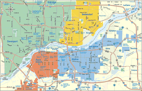
A color-coded wayfinding system has been initiated in the Quad Cities to help you find your way to area attractions. This system uses four colors to represent four quadrants in the Quad Cities – Davenport, Bettendorf in Iowa, and Rock Island, Moline/East Moline in Illinois. Identifying headers on signs around the area have the appropriate color so that the visitor knows, by color, which quadrant he or she is in, and to which color he or she will have to travel to reach other attractions. The colors on the map below reflect the colors for each city and the colors used in our wayfinding system.
|
Rock Island |
Moline & East Moline |
Davenport |
Bettendorf |

Press Release About Wayfinding in the Quad Cities
After years of talking about and working toward a wayfinding system in the Quad Cities area by the public and private sector, it’s finally becoming a reality.
With its multi-city, bi-state divisions, the Quad Cities area can become a confusing place to navigate. Certain area characteristics can be disorienting with the East-West orientation of the Mississippi River and continuous streets whose names change between cities. And because the cities are contiguous, people are unaware when they have left one city and entered another.
The Riverboat Development Authority in 2000 provided the first grant to fund the design of the system. Corbin Design of Traverse City, Michigan, (www.corbindesign.com) – the nation’s leading firm on wayfinding – was hired to create a wayfinding plan for the area.
“The designer of the wayfinding system, Jeffrey Corbin, is also an architect; and his good organization and structure shows,” said Kathy Wine, Executive Director of River Action. “I’m very excited about the new Quad Cities signage.”
A new graphic divided into color-coded quadrants with the river between represents the Quad Cities’ topography and the symbol is used on all wayfinding directional signs.
This color-coded system will help travelers know when they are entering or leaving a community; unite the Quad Cities’ attractions and destinations as a single metropolitan area; and assist visitors and newcomers alike better understand the lay of the land. The consistent use of one color in a city should also help it make it more identifiable, and provide directional information when individuals need it most.
“Wayfinding is more important than just a tourism attraction. It will promote economic development for all,” said Joe Taylor, President/CEO of the Quad Cities Convention & Visitors Bureau. “Potential residents, homeowners, business owners, college students, and employees will benefit from the improved public image – the helpful graphics and enhanced experience of not only visiting but living in the Quad Cities.”
Corbin Design, with input from city officials and key community organizations, pinpointed 217 wayfinding signs directing visitors to 85 destinations in the Quad Cities that they shared with the public in 2006.
The cost for the wayfinding system design work was just over $100,000 supported by grants from the Riverboat Development Authority, Scott County Regional Authority, and River Action via the Illinois Public Sector.
There will be new color-coded signs along state highways and city streets identifying the city entered with directional signs to attractions, venues, public parking, and adjacent cities.
When a Destination Review conducted by consultant Bill Geist was done in January 2007, it continued to remind community leaders that the Quad Cities remains a large, complex, and difficult-to-get-around destination by those who are unfamiliar with the community, and a wayfinding system was still needed.
“The Quad Cities is investing in wayfinding to demonstrate that it is a tourism destination by providing superior customer service and exceeding visitor expectations,” Taylor said.
In September 2007, the Riverboat Development Authority challenged each city to implement the wayfinding system in unison by providing a $70,000 matching grant. And in May 2008, it was announced that a second grant will reimburse 20 percent of the costs for Davenport, Bettendorf, Moline, Rock Island, and East Moline to install the wayfinding signs. The cities’ combined costs are almost $85,000.
All of the wayfinding signs in Bettendorf and Rock Island are currently installed. East Moline and Moline will be finished in the next few days. Davenport estimates they will be finished by mid November.
What do City Leaders Say
“The idea for the wayfinding system has been a long time coming. The system will be a wonderful addition to each city’s signage. Not only will it assist visitors, but it will show the continued support the communities in our area have for each other. This is a progressive move that will benefit everyone,” said City of Bettendorf Mayor Mike Freemire.
“Wayfinding signage is a great idea for helping people navigate the riverfront and all the attractions the Quad Cities has to offer. It’s another example of how cooperation among cities shows that we are all livable communities with a lot to offer visitors and residents alike,” said City of Davenport Mayor Bill Gluba.
Those of us who have called the Quad Cities home all of our life know the boundaries of our cities, but for visitors it can be confusing. The new Wayfinding system is an easy to understand, color coded system that will make our community more user friendly,” said City of East Moline Mayor John Thodos.
“The new wayfinding system allows the Quad Cities to come together as one destination while preserving the unique characters of each community,” says City of Moline Mayor Don Welvaert.
“The Wayfinding System provides us with an excellent method of making the Quad Cities region more friendly and accessible to visitors to our area. With our multiple jurisdictions and a river that runs east to west, the new signage will help newcomers find their way more easily, around our diverse and beautiful area,” said City of Rock Island Mayor Mark Schwiebert.
History of the Issue
- 1991 – Bi-State Regional Commission Survey of visitors to Riverboat casinos.
- 1996 – River Action initiates RiverWay.
- 1997 – John Deere Pavilion’s study reveals signage and wayfinding challenges.
- 2000 – Corbin Design hired by grant from Riverboat Development Authority.
- 2002 – 23rd Avenue/42nd Avenue/Colona Road renamed “Avenue of the Cities.”
- 2004 – Scott County Regional Authority grant.
- 2005 – River Action via Illinois Public Sector grant awarded.
- 2005 – IA and IL DOT’s approve colored headers with standard green directional signage.
- 2006 – Signs identified by Corbin Design and approved by cities.
- 2007 – Bill Geist’s Destination Audit reinforces need for Quad Cities wayfinding system, not just for tourism, but for economic development and workforce recruitment.
- 2007 – Challenge grant from the Riverboat Development Authority.
- 2008 – Installation of signs.


